TRANSLATION :
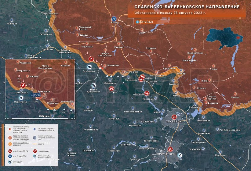
Situation on the Slavyansko-Barvankivsk direction
by the end of August 28, 2022
While the offensive against Slovyansk has stalled, the Russian Armed Forces continue position fighting near Malaya Kamyshevakha and Brazhkovka, trying to expand the security zone around Izyum.
▪️The Russian Armed Forces lost control of the key heights south of the Brazhkovka-Suligovka-Dolgenkoye line in the Barvenkiv direction as early as August 10. The heights are in the neutral zone and are sometimes climbed by AFU units, which are immediately driven away by artillery fire.
At the moment, the Russian Armed Forces remain present in Brazhkovka and Suligovka, while the southern part of the village in Dolgenkoye is in the combat zone. Conditionally, the AFU hills are only 1 kilometer from the outskirts of the villages.
▪️ Last week, the RF Armed Forces made repeated attempts to storm Hill 204.7 to the west of Brazhkovka: from the hill the road to Vernopolye opens up, from where the Ukrainian missile defense systems are operating.
At the moment, the height is controlled by the AFU.
▪️ Fighting is taking place on the outskirts of the village of Kopanki: the Russian Armed Forces are holding their ground on the border of the village and the heights to the south, preventing the AFU from advancing further.
▪️ The control post of the 93rd AFU brigade is located in Dmitrovka: the AFU is unable to advance further north. New APC units of the AFU were transferred to the front to counter the Russian Armed Forces.
▪️ Russian missile forces and artillery are striking the rear positions of the AFU in Kurulka, Adamovka, Dolyna, Krasnopolye, Slovyansk, Kramatorsk and the heights occupied by the AFU on a daily basis.
Map in high resolution
Foreign versions of Slavyansk direction map: DE | EN | ES | FR | IT
#dijest #Donetsk #Izum #map #Russia #Slavyansk #Ukraine #Kharkiv
Source: @rybar
Source : Сolonelcassad
Link : https://t.me/boris_rozhin/61618
Date : 2022-08-28T20:32:50.000Z
ORIGINAL :
Обстановка на Славянско-Барвенковском направлении
к исходу 28 августа 2022 года
Пока наступление на Славянск застопорилось, ВС РФ продолжают позиционные бои под Малой Камышевахой и Бражковкой, пытаясь расширить зону безопасности вокруг Изюма.
▪️На Барвенковском направлении ВС РФ ещё в десятых числах августа утратили контроль над ключевыми высотами к югу от рубежа Бражковка — Сулиговка — Долгенькое. Высоты находятся в нейтральной зоне, иногда на них поднимаются подразделения ВСУ, которых тут же прогоняют огнём артиллерии.
На данный момент в Бражковке и Сулиговке сохраняют присутствие ВС РФ, в Долгеньком южная часть посёлка находится в зоне боёв. Условно ВСУ холмы находятся всего лишь в 1 километре от окраин сел.
▪️ На прошедшей неделе ВС РФ предпринимали неоднократные попытки штурма высоты 204.7 к западу от Бражковки: от холма открывается дорога на Вернополье, откуда действуют украинские расчёты ПТРК.
На данный момент высота контролируется ВСУ.
▪️ Бои идут на окраине села Копанки: ВС РФ держат оборону на границе посёлка и расположенных южнее высот, не давая ВСУ продвинуться дальше.
▪️ КП 93 бригады ВСУ расположено в Дмитровке: продвинуться севернее у ВСУ не получается. На фронт были переброшены новые расчеты ПТРК ВСУ для противодействия ВС РФ.
▪️ Российские ракетные войска и артиллерия ежедневно наносят удары по тыловым позициям ВСУ в Курульке, Адамовке, Долине, Краснополье, Славянске, Краматорске и занятых ВСУ высотах.
Foreign versions of Slavyansk direction map: DE | EN | ES | FR | IT
#дайджест #Донецк #Изюм #карта #Россия #Славянск #Украина #Харьков
Источник: @rybar